A DAY ON MONTJUÏC
I
The long hill of Montjuïc lies parallel to the coast between the River Llobregat delta (with the airport) and the city centre (see the opening scene of The Fifth Tale). It offers a welcoming “green lung” parkland escape from the densely packed city, as well as fantastic views from its castle-capped summit nearly 200 metres above sea level. This excursion describes an easy walking route from the top of the hill down to Plaça Espanya, and passes the main attractions that Montjuïc has to offer. Allow two hours for the walk itself, extending this to fill up to the entire day if you wish to enter the museums and other paying sights. The simplest and most direct way to reach the top of the hill is to take the 150 bus from beside either of the two towers of Plaça Espanya (metro L3 Green Line: leave the subway from salida Fira Montjuïc). The 15-minute busride goes almost all the way to the top of the hill (last stop: Castell) where steps lead up to the castle ticket office. An alternative route is to ride the funicular (integrated with the T10 card) from Paraŀlel metro station (L3 Green Line) then connect with the 150 bus from immediately outside the funicular station, or take the cable car from here, which is fun but costs €12 and is not integrated into the T10.
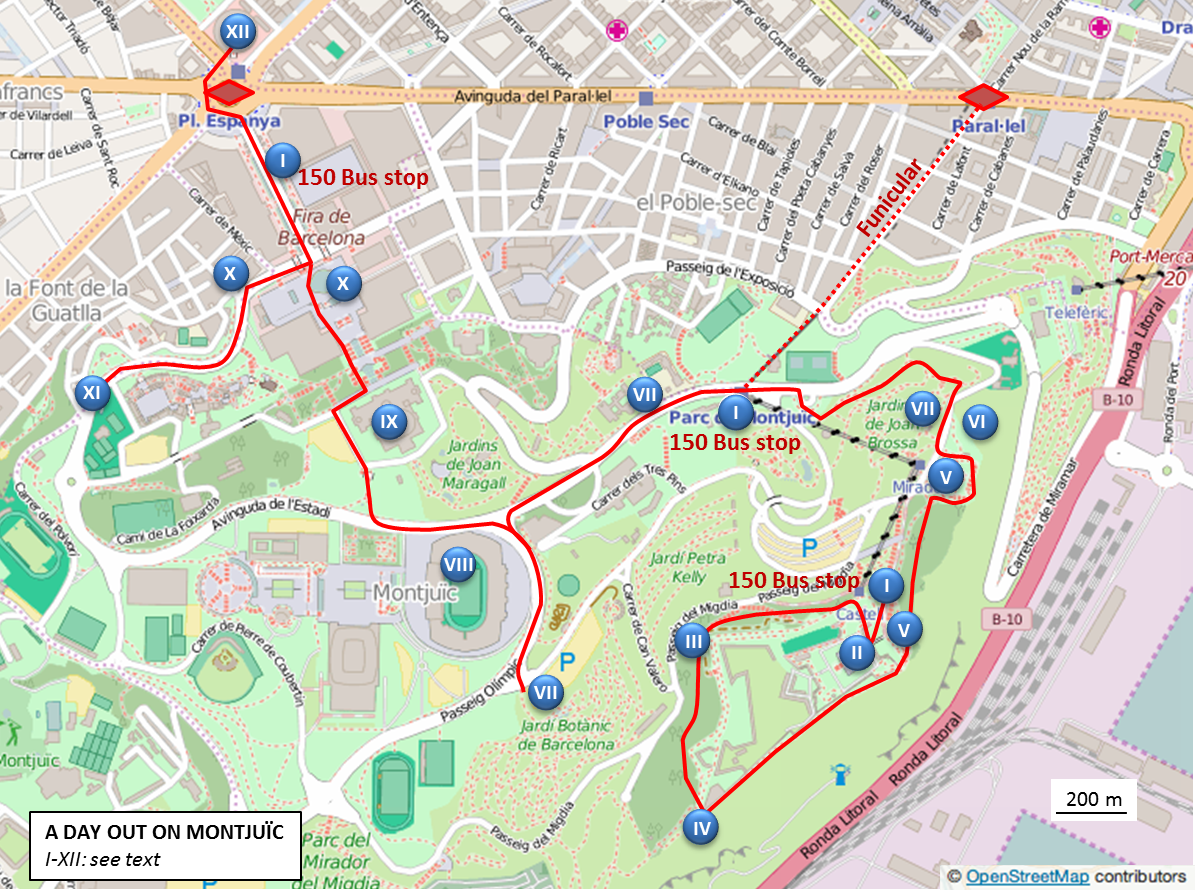
II
From the bus stop climb the steps to the castle front entrance (€5) in Pl. Castell. The castle, built of local brown sandstone and perhaps better described as a military fortress, is an 18th century reconstruction and enlargement of the original much simpler fort built in 1640 at the start of the Reaper’s War (see The Seventh Tale). After the (optional) visit to the castle, The Traveller recommends walking anti-clockwise around the castle outside its walls, leaving from Pl. Castell and keeping the castle and (now dry) moat on your left, initially passing the upper cable car station on your right.
III
The circuit of the castle takes 20-30 minutes, with pine forest to the right and the moat and castle always to the left. The track follows the landward side of the hilltop ridge, where intense all-day fighting on 26 January 1641 between Catalan rebels (with their French allies) and troops loyal to the King of Spain finally yielded what to many was a highly unexpected result. The Montjuïc defence is led by the young Scottish nobleman George Stewart, Ninth Seigneur d’Aubigny. Currently fighting for the French, d’Aubigny will die battling in the English Civil War the following year, aged twenty four (from: The Battle of Montjuïc in Barcelona Time Traveller: Twelve Tales). The wide sandy track bears left as it turns south around the western side of the castle, now crossing the ground where the Catalan Metallurgists put up an effective defence against the troops of the Irishman John O’Neill, the self-styled Third Earl of Tyrone, during the initial stages of the Battle of Montjuïc.
IV
After 10 minutes the track reaches a prominent boulder blocking traffic. Here either shortcut down to the left to reach the coastal path at the triangular bastion ahead or, if access is denied here, continue on the main track for a few more minutes descending to a red brick building on the right opposite which (to your left: green jogging route sign) the coastal path leads back to the castle walls at the triangular bastion. With these walls still on your left and fine views of the harbour below, the path runs back between the castle and the steep coastal cliff. It was far below here, on the beach existing before the modern port, that the Reaper’s War was ignited by the murderous events of 7 June 1640, a day that came to be known as Bloody Corpus (see The Fifth Tale: Death on Drassanes Beach).
V
After passing a prominent pine tree on the left the path finally reaches steps leading up to the left (with views to the castle bridge entrance). Don’t climb these steps but continue on the path which descends through pine forest with views eastwards across the city to the Costa Brava beyond. The path passes exposures on the left of the rocks that form Montjuïc. These are mostly brown sandstones deposited as sands on the seafloor in Miocene times around twelve million years ago, then later raised above sea level on geological faults that slice through the crust beneath Barcelona and create the scenic template for the city (for those interested in geology see the Geologist’s Association book The Geology of Barcelona: an urban excursion guide; https://www.geolsoc.org.uk/Geoscientist/Archive/November-2012/Book-Reviews). Continuing downhill through pine trees, keeping right, the path becomes paved and descends to pass a fountain on the left and then reaches (right) steps that lead to the viewing platform area known as the Mirador de l’Alcalde (Mayor’s Viewpoint) for another spectacular view of the harbour.
VI
Now move down to the nearby lower viewing platform for a grand view over the city. With Barcelona spread out below here at the eastern end of Montjuïc one can gain an insight into the underlying shape of the city. From the Collserola Hills behind and to the left of Gaudí’s La Sagrada Familia the city surface runs down to the flat shoreline to the right of the prominent Agbar Tower. This gentle slope is a “piedmont” known as the Pla de Barcelona (as mentioned in the previous Medieval city highlights) and it ends abruptly against the hills behind the city which, like Montjuïc, are cut by geological faults. The unusual geology of Barcelona, with old hard rocks forming the hills and young soft rocks the lower ground, has exerted a strong influence on urban development. The backdrop of the Collserola Hills has inhibited expansion inland and constricted growth along a densely packed northeast to southwest coastal strip. The pressure generated by the drive for urban expansion has progressively pushed back the shoreline. The original city founded by the Romans (where the cathedral is now) projected into the sea as a low isthmus (Mons Taber: later Mont Tàber in Catalan) whereas by modern times the coast, now lying to the right of the Ciutadella Park and towers at Port Olímpic, has migrated seawards by more than a kilometre. From this viewpoint you can spot all the main city landmarks: La Sagrada Familia, the Agbar Tower, the long green strip of Ciutadella Park, the Port Olímpic tower and coast and, closer into the city, the Cathedral, the rose window-bearing front entrance of the church of Santa María del Mar, and directly ahead the Colon (Columbus) Monument at the end of La Rambla.
VII
Continue from this lower viewpoint, passing a kiosk to the road below the intermediate station of the cable car. Cross this road at the zebra crossing and turn right to walk past the Plaça de Sardana sculpture and descend to reach an entrance on the left to the small park of Jardins de Joan Brossa. Look at the map displayed here to locate the Plaça de Dante on the opposite side of the park. There are various routes to choose from, perhaps the easiest being to enter the park, turn immediately right then first left to pass a “reflector parabolic” and reach a drinking water font where steps lead down to a path. This path runs ahead to pass a sculpture (left) in memory of Joaquim Blume Carreras, the outstanding Barcelonan Olympic athlete killed in a plane crash when only 25 years old, with views (right) to the Collserola Hills. Continue on the same path which becomes paved and drops to the gates at Plaça de Dante.
VIII
Emerging from the park at Plaça de Dante (No. 50 bus terminus) turn left (with a fountain on the right) and continue to reach the front of the funicular entrance where you cross the road at traffic lights. Now continue along the road in the same direction towards more of Montjuïc’s attractions. Passing a sign to the Olympic Sport Museum (Museu Olímpic) you firstly reach the popular Joan Miró museum (€12) on the right. Continue along the road, crossing traffic lights to locate the zebra crossing (left) in front of the Olympic Museum. Cross the zebra and keeping this museum on your left (and the Olympic Stadium on your right) climb the road ahead to locate the botanical gardens (€3.50). Now return to the Olympic Museum and turn left to pass by the front entrance of the stadium, which was built in 1927 for the 1929 Expo and renovated in 1989 for the 1992 Olympics. Cross the zebra crossing in front of the stadium and turn left to pass a Korean sculpture (right). Continue on, passing the stadium on your left, to reach a sign pointing right down to the Pl. Espanya and MNAC museum. Turn right here, down broad concrete steps to a mechanical escalator leading down to the side of the National Palace housing the National Art Museum of Catalonia (MNAC).
IX
Keep the Palace on your right to locate the front entrance to MNAC, where tourists gather to enjoy the splendid view down across the Magic Fountain to the Plaça Espanya and the Collserola Hills beyond. Refreshments are available here, but The Traveller Recommends going inside the museum building (no payment necessary but you must pass security) to locate the coffee shop hidden in the Great Hall at the back of the National Palace, another building designed for the 1929 Expo. A visit to the many MNAC exhibits costs €12 (valid for 2 days: check website for discounts and times when entry is free). The Traveller’s Recommendation is not to miss the world class exhibition of 11th-13th Century Romanesque Art, and to seek out the works of local artists Fortuny, Casas and Rusiñol in the Modern art section, especially if you plan a visit to Sitges.
X
Descend the steps then escalator in front of MNAC to pass the ever-popular Magic Fountain (check the web for show times), descend more steps to cross the road and then turn left to locate the Caixa Forum cultural centre (€4) on the right, housed in the distinctive modernist building of a textile factory designed by Puig i Cadafalch. The building alone is of special interest, added to which are various exhibitions available to view as well as a cafe to take a break from your sightseeing efforts.
XI
With the Forum on your right, consider continuing climbing up the road for another 10 minutes, curving left then right to reach the entrance towers to the Poble Espanyol (€12, reducing to €7 for evening entry). This is a slightly surreal reproduction of Spanish towns and villages, also constructed for the 1929 National Expo. It will not be to everyone’s taste and is not cheap, but if time allows then The Traveller considers it curious enough to merit a visit, preferably in good weather.
XII
Return to below the Magic Fountain and turn left to the twin towers and huge roundabout of the Plaça d’Espanya. The end of the excursion lies directly ahead: the rooftop of the converted Neo-Mudéjar-style bullring Las Arenas. This can either be reached by circling the roundabout at street level, or diving into the subway system and locating the exit marked sortida Tarragona. Now a modern shopping centre, the original bullring was inaugurated in 1900 and used until 1977 (bullfighting is banned in Catalonia). Enter the shopping centre and take the indoor lift to the fourth floor then an escalator to the outside fifth floor terrace. Completely restructured, the new commercial centre opened in 2011 and its panoramic rooftop terrace offers a grand 360 degree view of the city and a selection of restaurants. Viewing eastward towards Gaudi’s Sagrada Familia look down to spot the modernist creation of Casa Fajol (1912) designed by the architect Josep Graner i Prat and crowned by a giant colourful butterfly (La Casa de Papallona: Butterfly House).